|
|||||
| Orientation | |||||
| The Takao Club is often asked to explain where they are and what this site is about, and so provides this 'Orientation' page to help you get your bearings. | |||||
|
|
|||||
|
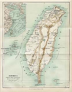
The Takao Club is based in modern-day Kaohsiung on the island of Taiwan. The island has been colonised by several countries in the past, such as China, Spain, the Netherlands and Japan, and has served as a refuge for notable counter-revolutionaries, such as Cheng Chen-kung and Chiang Kai-shek. Depending on your viewpoint, Taiwan is either a renegade province of China or an independent, democratic republic. Regardless of the geo-political semantics Taiwan is an island with a fascinating and complex history and an equally fascinating and complex ethnic mix. Malayan, Chinese and Caucasian blood courses through the veins of the population. The 1896 map on the left shows where we are on the globe. The island then being known as Formosa. You can click on the map to see a larger image. |
|
||||
|
|
History can go back forever, but the Takao
Club is mainly focussed on the 19th century period when the British
traders held
sway.
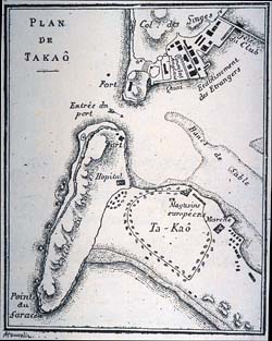
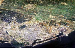
It can be asserted that the growth of Takow, later Takao, and now Kaohsiung, can be traced back to that period of sugar and opium nearly 150 years ago. On the left is a map (click to enlarge), drawn for the French consul at Canton, Camille Imbault-Huart, around 1890. The map, with the open sea to the left and the lagoon (port) to the right, shows the village of 'Ta-Kao' on the southern shore and the foreign settlement on the northern shore of the lagoon. The bottom bit of land, where Takow originally lay, is present-day Chi-hou on Chi-chin Island. This can be seen today in the bottom centre of the aerial photograph below (please note that all map images can be enlarged). |
||||
|
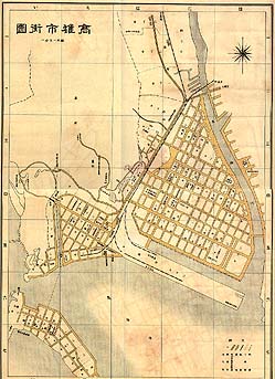
In 1895 the Japanese took over control of Taiwan. The new rulers were
quick to sea the possibilities that the port of Takow offered. In
particular it fitted in with their 'Look South' policy of moving nearer
to key resources.
By 1908 the Japanese had brought the railway right down to Takao harbour. They used this to transport materials to reclaim first the area of the smaller triangle of streets shown to the left on this 1935 map. Next the colonial rulers planned and created the area of Yen-cheng, which is the larger triangle of streets, again mainly built on reclaimed land, with Love River on its eastern side. The map is also interesting because the characters of its title, while reading 'Takao City' in Japanese, are read as 'Kaohsiung City' in Mandarin, the tongue of the new rulers who arrived in 1945. |
|
||||
|
|
Yen-cheng remained the commercial heart of Kaohsiung until the 1970s,
when industrialization caused the city to grow rapidly in population and
area.
The aerial photograph on the left (click to enlarge) shows just how much Kaohsiung has grown. Yen-cheng, Chi-hou, the old foreigners' settlement of ShaoChuanTou, and even the massive block of Ape's Hill now just occupy a small area at the bottom left on the picture. |
||||
| And still the city spreads. But our spiritual home is the old Takow Club which once stood at the end of a jetty off ShaoChuanTou. It has long since disappeared. | |||||
|
|||||